Trail Walking Le Val-Saint-Germain - Boucle entre Orge et Remarde - Photo

Boucle entre Orge et Remarde

 tracegps
tracegps

User

© OpenStreetMap contributors
Length
Length
23 km
Max alt
Max alt
167 m
Uphill gradient
Uphill gradient
400 m
Km-Effort
Km-Effort  
28 km
Min alt
Min alt
70 m
Downhill gradient
Downhill gradient
402 m
Boucle
Boucle
Yes
Creation date :
2014-12-10 00:00:00.0
Updated on :
2014-12-10 00:00:00.0

(0 Reviews)

Walking
Walking
4h30
Difficulty : Medium

Scan this QR Code to open this trail in the SityTrail application

FREE GPS app for hiking

Logo SityTrail SityTrail

IGN / Geographical institutes

Download SityTrail from the App Store Download SityTrail from Google Play

Logo SityTrail SityTrail World

The world is yours!

Download SityTrail from the App Store Download SityTrail from Google Play Download SityTrail on Huawei AppGallery

About

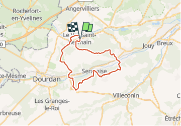
Trail Walking of 23 km to be discovered at Ile-de-France, Essonne, Le Val-Saint-Germain. This trail is proposed by tracegps.

Description

Au départ de l’église du Val Saint Germain, cette boucle franchit l'Orge à Saint Chéron, passe par Sermaise et plusieurs hameaux en rive Sud de l’Orge avant de la franchir à nouveau à Roinville. Elle rejoint et longe ensuite la Remarde qui arrose le Val Saint Germain.

Elevation profile

Photos

Positioning

Country:
France
Region :
Ile-de-France
Department/Province :
Essonne
Municipality :
Le Val-Saint-Germain
Location:
Unknown
Start:(UTM)
430790 ; 5379588 (31U) N.

Trails nearby

Trail Walking Sermaise - 2018-09-26 Rando Sermaise - Photo
Walking
jchezlemas

Walking

Easy
(1)
Sermaise, Ile-de-France, Essonne, France
12.3 km | 15 km-effort
3h 15min
Yes
Trail Nordic walking Dourdan - Forêt de Saint Arnoult - Photo
Nordic walking
Zygomat

Nordic walking

Easy
(1)
Dourdan, Ile-de-France, Essonne, France
8.6 km | 10.5 km-effort
1h 50min
Yes
Trail On foot Dourdan - La Remarde et le Marais - Photo
On foot
Annie Leduc

On foot

Medium
(1)
Dourdan, Ile-de-France, Essonne, France
18.9 km | 23 km-effort
5h 19min
No
Trail Walking Saint-Chéron - De Saint Chéron à Dourdan par les côteaux de la rive gauche - Photo
Walking
philippebenne

Walking

Difficult
(1)
Saint-Chéron, Ile-de-France, Essonne, France
13.5 km | 17 km-effort
3h 51min
No
Trail Walking Angervilliers - 2022-05-13_RD_Angervilliers - Photo
Walking
BMorin91470

Walking

Very easy
Angervilliers, Ile-de-France, Essonne, France
7.9 km | 9.3 km-effort
2h 3min
Yes
Trail On foot Angervilliers - La Mare des 3 Ruisseaux - Photo
On foot
PRO

On foot

Easy
Angervilliers, Ile-de-France, Essonne, France
3.3 km | 4.2 km-effort
56min
No
Trail On foot Forges-les-Bains - Grande boucle de randonnée de la Communauté de Communes du Pays de Limours - Boucle d'Angervilliers - Photo
On foot
PRO

On foot

Easy
(1)
Forges-les-Bains, Ile-de-France, Essonne, France
16.2 km | 19.1 km-effort
4h 20min
Yes
Trail On foot Dourdan - FR-PR 11 - Photo
On foot
PRO

On foot

Easy
Dourdan, Ile-de-France, Essonne, France
3.4 km | 4.1 km-effort
56min
No
Trail Nordic walking Saint-Chéron - carrière Saint chérion - Photo
Nordic walking
PascalROBINET

Nordic walking

Very easy
Saint-Chéron, Ile-de-France, Essonne, France
10.3 km | 12.3 km-effort
2h 32min
Yes


Close
My subscriptions